| The small city of Huaráz is the hub for all hiking
activity, and frequent rural buses transport enthusiasts to a variety of trailheads.
A
Casa de Guias, located just off the main street, will provide the latest information
about routes and mountain conditions, and can provide trekkers with a list of porters and
am
. eros, burro drivers, who can help carry gear on the long trek ahead. Along the main
street of Luzuriaga, colorful billboard signs lend distinction to an otherwise dull facade
of street-front shops. Most of these promote tourism in some form, so finding a
comfortable day tour, renting hiking gear, or buying souvenirs is as easy as locating the
proper agency by identifying its sign out front. A number of good restaurants (whose
status is often elevated to excellent after a long hike) serve up a variety of food and a
couple of lively peñas, featuring groups playing the traditional music of the
Andes, provide a place to loosen up before or after a strenuous four days' trekking. The Cordillera Blanca is full of striking views and unique
adventures. Hikes from one day to 10 are possible, combinations producing even more
possibilities if desired. Here limitations are only the result of a lack of imagination.
The past few years have, however, seen a dramatic
improvement in the situation as the center of terrorist activity moved away from the
sierra and into the coca growing areas of Peru, most notably the Huallaga Valley.
The highest mountain in Peru, Huascarán at 6,768
meters (22,200 feet), and what many consider to be the most beautiful in the world,
Alpamayo at 5,945 meters (19,500 feet), are just the toppings on an already rich cake. Glacial
lakes dot the landscape, and fresh running streams serve up tasty trout.
The days are warm and scented with eucalyptus. Snow-covered peaks
stretch as far as the eye can see.
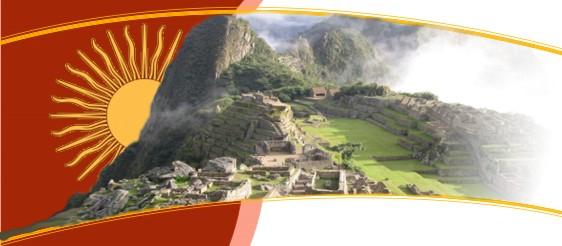
If you are
Planning A Trip Peru, we got the best options for you to
enjoy the best vacation of your life Trekkers wanting to get the legs and lungs in shape for
longer treks can start with a variety of short day hikes in the Huaráz area. Just above
the city is El Mirador, a scenic lookout marked by a huge white cross. The route
heads uphill east along city streets which eventually turn into a footpath beside an
irrigation canal lined with eucalyptus trees. Fields of wheat ripening in the sun add a
serene, pastoral feel.
At the top, the highest mountain in Peru, Huascarán,
dominates the northern horizon, the lower Vallunaraju (5,680 meters/1 8,600 feet) peeks
out over the foothills to the east, and the city of Huaráz sprawls below.
Another choice of many is the Pitec Trail to Laguna Churup. There is no public transport to this small village 10 km (6 miles) from the
center of Huaraz, but often a taxi driver can be persuaded to navigate the terribly rough
road to Pitec. Walking is an option, but it's nicer to be fresh at the trailhead and then
walk back down to Huaraz afterwards.
The trail begins at the "parking lof 'before the
actual village of Pitec is reached. A wellworn footpath heads north up a ridgeline and the
Churup massif rises just above 5,495 meters (18,000 feet) in the distance. At the base of
this mountain is the destination of the hike, Laguna Churup, fed by the glacial melt-off
and surrounded by huge boulders. A picnic lunch and a midday siesta in the warm sun reward
the effort of getting here. A leisurely hike back to Huaráz follows a cobbled road
through campesino homesteads.
The Llanganuco to Santa Cruz Loop: One of the most
frequently hiked trails is the 5-day loop into the Cordillera Blanca which begins at the
Llanganuco lakes. The route passes under a dozen peaks over 5,800 meters(19,000 feet) and
panoramic views abound. Buses frequently leave Huaraz, loaded with an assortment of
campesinos, their chickens, cuyes and children, for the small village of
Yungay. Here camionetas, small pick-up trucks, wait in the plaza to transport hikers and
sightseers up the valley to the dazzling, glacier-fed lakes of Llanganuco.
The trailhead lies a few kilometers above the lakes, near
the Portachuelo (high pass) of Llanganuco, and the trek begins with a descent
towards the village of Colcabamba. Immediately the steep face of Chopicalqui (6,350
meters/20,800 feet) towers over the trail like a sentinel and soon a few thatchedroofed
houses come into view. A sampling of local cuisine may be possible here.
At this point, the trail begins a steady ascent up the Huariparnpa
Quebrada (narrow valley). The snow-capped peaks of Chacraraju (6,110
meters/20,000 feet) and Pirámide (5,880 meters/19,285 feet) provide splendid photo
opportunities, and a chance to rest, as the trekker labors up the steepening trail towards
the high pass of Punta Union. In the last hour before sunset, as camp is set up,
the mountains are cast in the silver and pink of "alpenglow."
At over 4,750 meters (15,500 feet), Punta Union becomes
both literally and figuratively the high point of this journey. Taulliraju, over
5,830 meters (19,000 feet), glistens in the midday sun, and a number of glacial lakes lie
like scattered jewels in the distance. The valley below opens up to reveal a wide stretch
of snow-capped peaks, a mere hint of the magnitude of the Cordillera Blanca, and huge
Andean condors can often be seen soaring high above the pass.
As the trail descends toward the village of Cashapampa, the
scenery changes from dramatic mountain vistas to open, marshy pasture land where herds of
llamas and goats graze. Farther along, the trail narrows as it begins to wind through
forests of stunted trees and follows the easy meandering of a small stream.
Mountaineering:
For the more adventurous and technically-minded mountain enthusiast, the Cordillera
Blanca is unrivaled for the pursuit of mountaineering. With glacier-covered peaks varying
in altitudes from 5,495 meters (18,000 feet) to 6,795 meters (20,000 feet), and technical
levels from very easy to extremely difficult, there is something for everyone. However,
because all climbing here is at high altitude, and any glacier travel requires technical
knowledge, climbing in the Cordillera Blanca should be attempted by those with experience.
Besides the usual trekking equipment, a rope, ice axe, crampons and ice stakes or screws
are necessary.
Trekkers generally don't experience anything more than soroche,
or mild altitude sickness, but at higher altitudes serious complications can occur.
Pulmonary
Edema occurs when the lungs begin to fill With fluid. Early symptoms include a dry,
incessant cough, a rattling sound and tightness in the chest. Cerebral Edema occurs
when fluid collects in the brain. Symptoms include loss of coordination, incoherent
speech, confusion, and loss of energy. Both of these illnesses are extremely serious and
possibly fatal. The only cure is an immediate descent to a significantly lower altitude.
The victim is usually the last one aware of the problem, so it's essential that each
person in the group keep an eye out for symptoms in the others. Another high-altitude
problem is hypothermia, or exposure. This occurs when the body loses more heat than
it can replace. The symptoms begin with uncontrolled shivering that will eventually cease,
though the body is still cold. Lack of coordination, confusion, drowsiness and even a
feeling of warmth are other symptoms. A victim suffering from hypothermia will need to be
immediately dried-off, placed in a warm sleeping bag, and given warm liquid to drink. In
advanced cases, the victim will not be able to generate any body heat and will need the
warmth of other bodies to get his temperature back to normal. Hypothermia is prevented by
staying warm and dry. Wearing wool or a synthetic insulating material next to the skin
will help hold in warmth, even when wet. Cotton has no insulating properties and will
actually draw off body heat when wet. Layering clothes is an effective way to regulate
body temperature during times of exertion and rest. Food also helps stove the internal
generators, so eating quickly assimilated food like chocolate will help keep the system
functioning.
Many climbers feel that acclimatization comes with activity
- getting the legs in shape for the more demanding climbs is as important as having the
lungs working at capacity. To this end, several short warm-up climbs are favored.
Nevado Pisco, just over 5,800 meters (19,000 feet), is popular for its steep, yet quick
ascent, and the views from the saddle are some of the finest anywhere in the Cordillera
Blanca.
The approach to base camp begins just above the Llanganuco
lakes. The 5-km (3mile) hike follows a footpath along the crest of a lateral moraine and
gains 750 meters (2,460 feet) in altitude. Camping is in a flat, grassy area below an
incredibly steep moraine, which unfortunately must be negotiated the next day. Some groups
choose to continue on past the base camp, tackle the difficult moraine the same day, and
continue on up to the high campjust below the glacier.
An early-morning start from here allows climbers to make
the summit and be back in camp for afternoon tea. The next day descent is quick and
climbers are usually back in Huaraz by evening.
Peru's highest peaks: When the acclimatization to
altitude is adequate, and climbers are ready for some real work, they'll often head for
the highest mountain in Peru, Huascarán. There are two huge summits separated by a
lower saddle giving a sort of double
humped camel look. The south summit at 6,768 meters (22,205
feet), is 113 meters (370 feet) higher than its north sister, and the most frequently
climbed.
The hike into base camp begins at the small village of Musho, where arrieros can be hired to help carry the heavy load of climbing gear and food
provisions to the first camp. The trail wanders through farmland and eucalyptus groves for
the first few hours, and then a sharp ascent above treeline finally leads to a flat,
grassy area known as Huascarán base camp.
Another two hours up a very steep ridge lies the moraine
camp and some climbers opt to make it to this point in one day. The loadrelieving burros,
however, can't make it up this section of the trail, so it means donning the heavy weight
and sallying forth.
It's usually on the second or third day when climbers pack
up at moraine camp and head for Camp One on the glacier. The hike starts with a scrambling
across rock slabs, the path marked with stone carins. At the glacier's edge it's a
question of finding the best access to the snow through sometimes massive icefalls.
Once on the glacier, the route up to the next camp will
often be "wanded" by previous climbing parties. Small flags are placed at
regular intervals for an easy descent afterwards and to avoid getting lost on the glacier
during a "whiteout" when clouds obscure everything. The climb up to Camp One is
unforgettable. Wide crevasses, icy cracks and massive pillars of tumbled ice are constant
reminders that glaciers are anything but static piles of snow.
Camp One at about 5,200 meters (17,000 feet) is a welcome
relief after five to seven hours of traversing the lower glacier, but the pleasure is
short-lived as the sun goes down and temperatures drop to well below freezing. It is in
this bone-chilling cold that climbers rise early the next morning and prepare to set off
for the final high camp at La Garganta (the throat) at 5,790 meters (19,000 feet).
This section is probably the most interesting of the entire
climb. About an hour after leaving camp and crossing a wide crevasse, the first technical
part of the route appears. A 30-foot, 70 degree ice wall must be climbed, and quickly
because it is a natural avalanche chute. Early morning is the best time as the snow pack
is still frozen and likely to stay in place. Above the chute, the route remains steep and
prone to avalanche activity. It's important, but extremely strenuous, to move as quickly
as possible, leaving little chance to rest the aching lungs and reeling head.
At La Garganta Camp it's difficult to do any more than set
up camp and melt and boil snow for a hot drink. Nightfall brings a dazzling array of
stars, but the intense cold quickly drives everyone into tents to nestle in warm sleeping
bags. At this altitude sleep can be elusive; it's a long night of tossing and turning and
trying to stay warm.
Another early morning finds climbers preparing for the
summit attempt. Stiff fingers attempt to sort out gear and groggy minds work out the plan
ahead. A small blessing is that the heavy equipment can be left behind in camp. All that's
needed are spare warm clothes, food, water and a camera for those magnificent summit
photos.
The summit route heads up across the saddle between the two
peaks of HuascarAn, and the climber is treated to a view of distant mountains set ablaze
in the early morning sun. Shifting south the climb ascends several steep snow slopes and
the first few hours involve zig-zag traverses up and up until the final approach is
reached.
Here the abstract concept of "forever" seems to
become tangible. Rather than being just one long, gradual slope to the summit, the climber
encounters a series of gentle inclines. From the high-point of one, a] I that is seen is
yet another. Each time, the climber summons what strength, both mental and physical, is
left and trudges on, and each time he finds only another long slog, and no sign of a
summit. At this altitude, about 6,700 meters (22,000 feet), breathing becomes so labored
that three or four breaths are needed for each step taken. Finally the tricks play out,
"forever" is ended, and the summit of the highest mountain in Peru is conquered.
|